Can you rent a yacht in Jesenice- do I need a license? The requirements.
Small boats (under a certain horsepower or length), electric boats, crewed yacht charters, gulet charters may not require a license. Larger boats or those with more powerful engines need a skipper’s license. Before you confirm your sailing trip to Trogir, please send us a copy and we will check it for you. You need to have the original copies on board, so don’t forget to take them.
To sail from Trogir, one of the following qualifications is necessary: ICC (International Certificate of Competence), Int. IPC (International Proficiency Certificate, USA), NauticEd SLC (International Sailing License and Credentials), RYA Day Skipper Course, valid Navigational and VHF licenses. Alternatively: ICC (International Certificate of Competence), Int. IPC (International Proficiency Certificate, USA), NauticEd SLC (International Sailing License and Credentials, Int.) OR: [UK] RYA Day Skipper Shorebased Certificate or higher, [USA] Sailing ‘Basic Keelboat’ or higher, [DE] ‘Sportbootführerschein See’ or higher, [FR] le Permis Plaisance Additionally, the following documents are necessary: Valid travel documents: USA citizens: EU regulations mandate USA passport holders to have at least three months of validity beyond the planned departure date from Croatia., European Union (EU) citizens: No visa required. Canadian citizens: No visa is required for stays up to 90 days.
If you do not have a skipper license, it is also possible to rent a boat with a skipper
Yacht charter in Jesenice – the main ports
The port of Split is the main destination for seagoing boats on the Adriatic Sea thanks to the strategic position of the Mediterranean region (ports of Venice and the Aegean Sea). Its rich history and numerous sights attract thousands of tourists day by day. In 2011 the port became the biggest in Croatia and the third biggest in the Adriatic region. Nowadays we can claim for sure that the city and its port are an inevitable destination of seagoing boats and all cruiser companies. In this way, it has great significance in yachting, both locally and internationally.
ACI Marina Split
The ACI Marina Split offers 348 berths for yachts of a maximum of 90 m. The breakwater provides outstanding protection from the raging sea and the southern winds. The water depth is 8 m. There are restaurants, bars, laundries and a fuelling station. Split sailing, bareboat charter Split
Port of Marina
There are 134 permanent berths for boats with a maximum length of 25 metres. The sea is 7 metres deep at the entrance. The port offers several good-quality services, and there is a bar and a restaurant. sailing in Vis, rent a boat Vis
Port of Trogir
This significant port offers 256 permanent berths for ships up to 70 metres long. The depth of the water is 20 metres. They provide several services such as laundry, fuel and maintenance. They also have drinking water, electricity and free Wi-Fi. Trogir sailing, rent a boat Trogir
Ports of Milna, Brač
Milna has 3 ports and can accommodate more than 300 boats. The largest is ACI Marina Milna, offering 170 berths for boats up to 40 metres. The depth of the seabed is 6 metres. You can choose from many quality services here, and you can refuel. Marina Vlaska is on the northern side of the Bay of Milna. It has 71 berths for boats up to 25 metres. The depth is 15 metres. Yacht Club Milna has 100 berths for boats up to 30 metres. The depth is 3 metres. Milna sailing, rent a boat Milna
Port of Sutivan (Brač
Sutivan is located on the westernmost part of the north coast of Brač. It is only 7 kilometres from Supetar. The port can accommodate smaller yachts, but larger boats can only anchor in front of the bay. The depth at the entrance is 6 metres, and 2-3 metres along the quay.
Port of Supetar (Brač
Supetar’s outer port is reserved for ferries and commercial vessels. In contrast, mostly smaller boats and yachts use the inner basin. The depth of the seabed at the entrance is 6 metres, 5 metres in the outer basin, and 3-4 metres in the inner basin. sailing in Supetar, boat hire Supetar
Port of Pučišća (Brač
The Port of Pučišća is located on the northeast coast of the island of Brač. It provides 25 berths for boats, of which 8-10 are usually available for yachts. The depth of the seabed along the quay is 1, 2-2, 3 metres, and 3, 5-4, 3 metres in the middle of the port.
Port of Sumartin
The peaceful, quiet Sumartin lies at the eastern tip of Brač. It is the youngest settlement on the island. From the marina, you can see Makarska. They are connected by ferry. The depth of the seabed is 1-3, 7 metres. Sumartin sailing
Marina Bol (Brač)
The port of Bol is located on the southern coast of Brač Island, about halfway between Milna and Sumartin. Because of its small size, it can be hard to find a free berth during the main season. The depth of the water is 6-7 metres near the entrance and 2 metres at the pier. They provide drinking water, electricity, laundry as well as cafés and restaurants. Information about Bol sailing, or rent a boat in Bol
Port of Omiš
The small Middle Dalmatian town lies by the estuary of the Cetina river; it is surrounded by huge canyons. The bora blows violently in the bay from many directions, and the southern wind also raises a heavy sea. The depth here is 4 m. Omis sailing, boat rental Omis
Port of Podstrana
The luxurious Marina Lav belongs to the Le Meridien Lav hotel complex. It can accommodate 74 yachts with a maximum length of 40 m. The depth varies between 2-2.8 m. There is a water supply, and electricity in each berth; moreover, a 24-hour security guard protects the area. sailing in Podstrana, yacht charter in Podstrana
Marina Baška Voda
The Marina Baška Voda can accommodate up to 180 boats up to 23 metres in length. The maximum depth of the seabed is 4 metres. The port has drinking water, electricity and a restaurant. You can even get medical help if needed. Information about sailing in Baska Voda, boat rental Baska Voda
Marina Ramova
The Marina Ramova is located in Krvavica, a town that administratively belongs to Baška Voda. It has 195 berths for boats up to 16 metres in length. The depth of the seabed is 3 metres. The port offers many excellent services. The restaurant can accommodate up to 150 guests at once.
Makarska Harbour
The port’s 225 metres long breakwater was completed in 2015. It provides protection from winds and waves coming from the south and southwest. The maximum depth of the seabed is 4.8 metres. The excellent services offered in the port include refuelling. Makarska sailing, rent a boat Makarska
Marina Tučepi
The marina is right next to Slatina Beach. It has 200 berths, 50 of which are reserved for visitors and 150 for local boats. Marina Tučepi can accommodate boats up to 20 metres in length.
Marina Podgora
The marina, southeast of Makarska, is open all year round. It can accommodate 220 boats up to 20 metres in length. The maximum depth of the seabed is 3 metres. There are drinking water, electricity and a crane. Podgora sailing, rent a boat Podgora
More info about yacht charter Dalmatia, Dalmatia sailing routes
More information about Jesenice
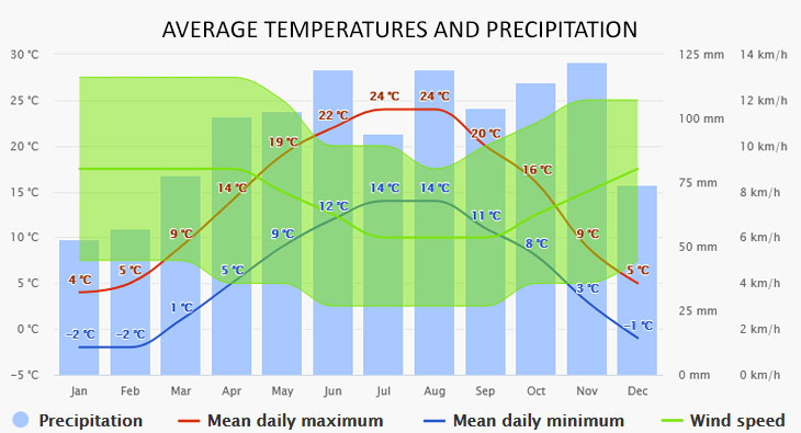
The climate diagrams are based on 30 years of hourly weather model simulations. They give good indications of typical climate patterns and expected conditions (temperature, precipitation, sunshine, and wind). The “mean daily maximum” (solid red line) shows the maximum temperature of an average day for every month for Jesenice. Likewise, the “mean daily minimum” (solid blue line) shows the average minimum temperature.
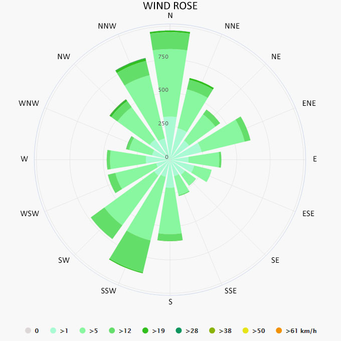
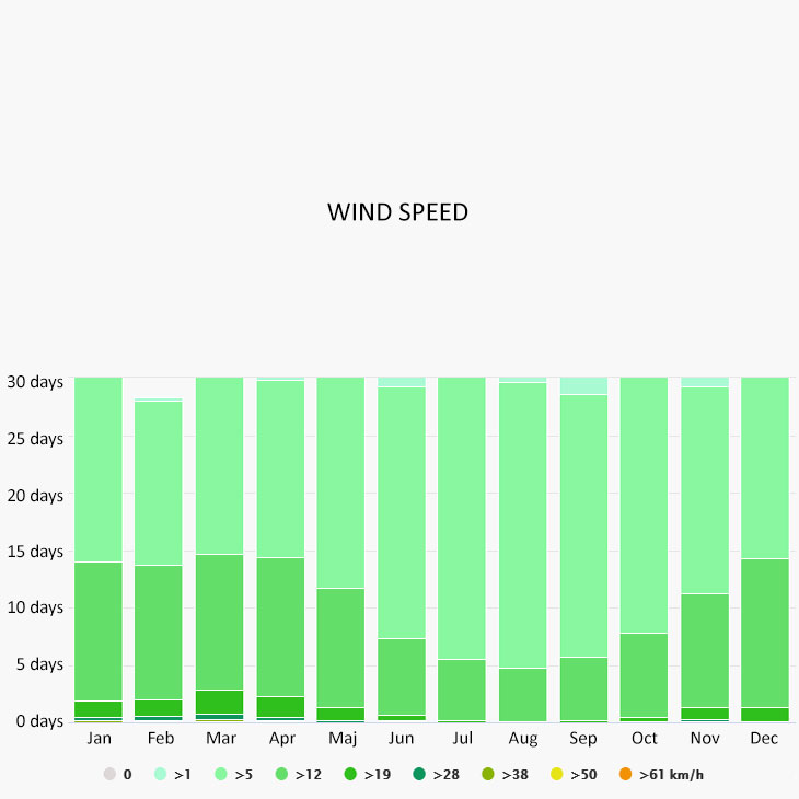
The wind rose for Jesenice shows how many hours per year the wind blows from the indicated direction. The diagram for Jesenice shows the days per month, during which the wind reaches a certain speed.