Renting a boat in Korcula & discovering the Dalmatian Coasts? Middle Dalmatia’s true gem, Korčula is located on the eastern side of Split Bay. It is bordered by Brač Island from the north, and by Korčula Island and the sea from the south. You can learn about the weather you can expect when yachting on Korčula Island, and we will also help you with useful tips on how to make a one or two weeks long yachting trip.
There are no boats on the list with your parameters?
We have access to a lot more boats than what we have listed on our site.
Send us this form and we will find the perfect boat for you. The shortest boat rental option is 1 day.
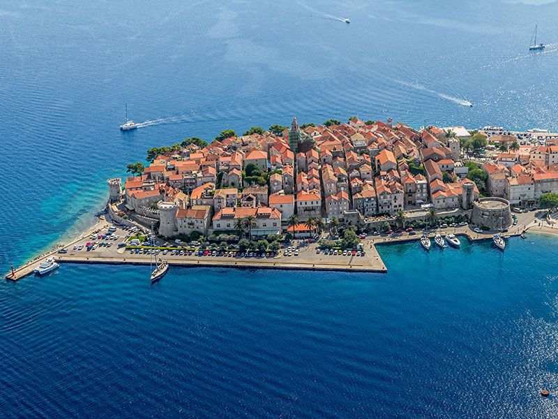
Location of Korčula
The picturesque Korčula is the sixth-largest island of the Adriatic. It is located in Dubrovnik-Neretva county, in Dalmatia, on the southernmost part of Croatia. The Pelješac Channel separates it from the Pelješac peninsula.
Can you rent a yacht in Korčula- do I need a license? The requirements.
Small boats (under a certain horsepower or length), electric boats, crewed yacht charters, gulet charters may not require a license. Larger boats or those with more powerful engines need a skipper’s license. Before you confirm your sailing trip to Trogir, please send us a copy and we will check it for you. You need to have the original copies on board, so don’t forget to take them. To sail from Trogir, one of the following qualifications is necessary: ICC (International Certificate of Competence), Int. IPC (International Proficiency Certificate, USA), NauticEd SLC (International Sailing License and Credentials), RYA Day Skipper Course, valid Navigational and VHF licenses. Alternatively: ICC (International Certificate of Competence), Int. IPC (International Proficiency Certificate, USA), NauticEd SLC (International Sailing License and Credentials, Int.) OR: [UK] RYA Day Skipper Shorebased Certificate or higher, [USA] Sailing ‘Basic Keelboat’ or higher, [DE] ‘Sportbootführerschein See’ or higher, [FR] le Permis Plaisance Additionally, the following documents are necessary: Valid travel documents: USA citizens: EU regulations mandate USA passport holders to have at least three months of validity beyond the planned departure date from Croatia., European Union (EU) citizens: No visa required. Canadian citizens: No visa is required for stays up to 90 days. If you do not have a skipper license, it is also possible to rent a boat with a skipperRent a boat in Korčula – the main ports
The island is an excellent starting-off point for sailing around further South-Dalmatian settlements and breath-taking islands. Get to know Korčula and the mooring sites of its vicinity.
Marina Vela Luka (Korčula)
The marina on the Island of Korčula has 45 berths for boats up to 17 metres in length. The depth of the seabed is 4 metres. The yacht pier is right next to the refuelling station. Vela Luka sailing.
ACI Marina Korčula
The marina provides 159 berths for yachts below 45 metres. The depth is 5 m. There are Wi-Fi, laundry, a petrol station and a garage repairing yachts. Furthermore, bars and restaurants await their guests. Korcula sailing, rent a boat Korcula
Lumbarda Marina
The marina lying in Lumbarda Bay is surrounded by a splendid natural environment. 115 yachts have free space here in total with a maximum length of 25-30 metres. The depth is 8 m. There is a water supply, electricity, shower rooms, bars and restaurants. As you would expect, it is open all year round.
Zavalatica Marina
The small marina in the southern part of the Korčula island is about 27 km from the old town of Korčula on the West. If you are pondering about eating out, go to the lovely restaurant by sea.
Marina Orebić (Pelješac peninsula)
The marina of the largest town of the Pelješac Peninsula has 220 berths for yachts up to 12 m. The depth is 2 m. As the large pier is for ferries and small passenger ships, you need to find another place for mooring. Korcula sailing, rent a boat Korcula
Marina Lovište (Pelješac peninsula)
Lovište lies in the wonderful bay of the Pelješac Peninsula in the Northwest. The marina provides 20 berths for yachts below 20 metres. Boatmen prefer this place for its tasty Dalmatian fish dishes.
Porto Rosso Marina
The marina of the Lastovo island provides 30 berths for yachts below 60 metres. The depth is 1.8-10 m. There is a water supply, electricity, Wi-Fi, laundry and healthcare services.
If you are bound to ship towards Korčula, do not miss out its fascinating holiday resorts! Orebić, Vela Luka, Biševo island, Vis, Stari Grad, Sućuraj and Lovište are all waiting for you. Read about Korčula island sailing routes or choose another yacht charter Dalmatia
Main sights in Korčula
If you love hiking, definitely visit the Vela Spila Cave above the Vela Luka bay. Or are you wondering about visiting interesting monuments? The main sights of Korčula are the Gothic-Renaissance Saint Mark Cathedral and the assumed home of Marco Polo.
Gastronomy of Korčula
The South-Dalmatian cuisine is primarily known for using ingredients like fish, sea fruit, vegetables and excellent quality olive oil. If you happen to sail around, do not forget to try Croatia’s best wines produced here. We highly recommend Grk and Pošip.
Beaches in Korčula
Vela Pržina (Lumbarda)
Vela Pržina is one of Croatia’s most popular beaches. It lies on the southern part of Korčula, in Lumbarda. There are cabins, sun umbrellas and sunbeds on its sandy shore. Moreover, we need to mention the great restaurants and bars with cool drinks.
Bilin Žal (Lumbarda)
A part of its shore is concrete ideal for pleasant strolls besides sunbathing. Besides Vela Pržina, Bilin Žal is also fairly popular by families with children. Owing to its crystal-clear water and the rich underwater world it is a great spot for diving. For gourmets, the restaurant beside the beach offers fish specialities.
Banje (Korčula)
The pebbled Banje is Korčula‘s oldest beach. Both tourists and locals prefer it. We highly recommend this beach providing many facilities for families with children.
Istruga Beach (Brna)
Istruga is near the settlement of Brna. It has a sandy shore where pine trees around the beach provide shade for tourists. Furthermore, there is a lovely beach volleyball court nearby. Although if you are rather keen on gastronomy, visit the restaurant nearby offering home-made sea specialities.
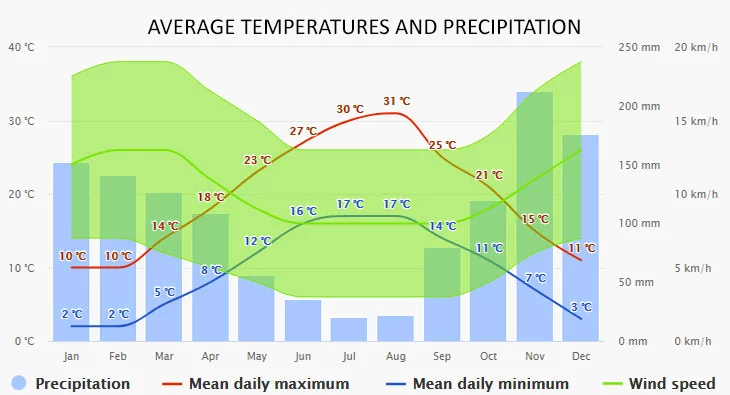
Korčula has a really mild Mediterranean climate. The average temperature in July is 26.9 °C. Regarding winds, the mistral blows in the summer whereas Jugo, bora and tramontana in the winter. Are you crazy about swimming or other water sports? The average temperature of the Adriatic Sea in August is 25.3 °C.
The climate diagrams are based on 30 years of hourly weather model simulations. They give good indications of typical climate patterns and expected conditions (temperature, precipitation, sunshine, and wind). The “mean daily maximum” (solid red line) shows the maximum temperature of an average day for every month for Korčula. Likewise, the “mean daily minimum” (solid blue line) shows the average minimum temperature.
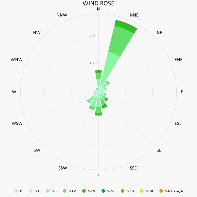
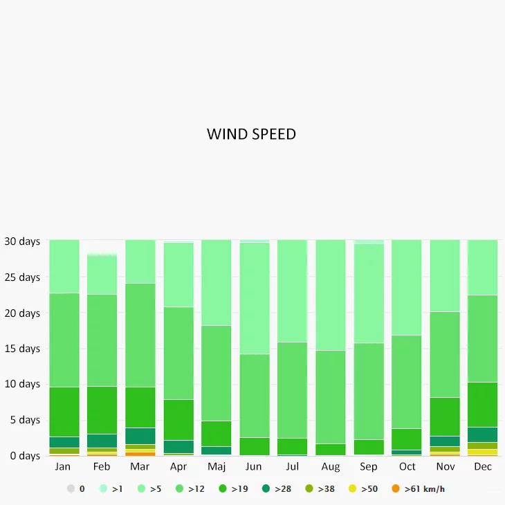
The wind rose for Korčula shows how many hours per year the wind blows from the indicated direction. The diagram for Korčula shows the days per month, during which the wind reaches a certain speed.
Day 1. Korčula (ACI Marina Korčula) – Samograd-bay 12, 93 km (8, 03 nm), Day 2. Samograd-bay – Trpanj (Pelješac) 30, 84 km (19, 16 nm), Day 3. Trpanj – Makarska 38, 30 km (23, 80 nm), Day 4. Makarska – Split (ACI Marina Split) 53, 39 km (33, 18 nm), Day 5. Split – Rogoznica 45, 67 km (28, 38 nm), Day 6. Rogoznica – Vis (Marina Vis) 58, 50 km (36, 35 nm), Day 7. Vis – Vela Luka – Korčula (ACI Marina Korčula) 95, 89 km (59, 68 nm)
Day 1. Korčula (ACI Marina Korčula) – Orebić 3, 72 km (2, 31 nm), Day 2. Orebić – Vela Luka 53, 84 km (33, 45 nm), Day 3. Vela Luka – Biševo-island (Porat) 62, 14 km (38, 61 nm), Day 4. Biševo-island – Vis (Marina Vis) 26, 16 km (16, 25 nm), Day 5. Vis – Stari Grad (Mooring Bouys) 36, 41 km (22, 62 nm), Day 6. Stari Grad – Sućuraj
61, 22 km (38, 04 nm), Day 7. Sućuraj – Lovište – Korčula (ACI Marina Korčula) 38, 57 km (23, 97 nm)
Day 1. Lumbarda – Trstenik 19, 54 km (12, 14 nm), Day 2. Trstenik – Dubrovnik (Porto Di Dubrovnik) 66, 54 km (41, 34 nm), Day 3. Dubrovnik – Sobra 42, 71 km (26, 54 nm), Day 4. Sobra – Lastovo (Porto Rosso) 66, 48 km (41, 31 nm), Day 5. Lastovo – Vela Luka 42, 30 km (26, 28 nm), Day 6. Vela Luka – Lovište 42, 09 km (26, 15 nm), Day 7. Lovište – Orebić – Lumbarda 59, 69 km (37, 09 nm)
Day 1. Vela Luka (Marina Korkyra) – Proizd-island 8, 29 km (5, 15 nm), Day 2. Proizd-island – Lovište (Pelješac) 36, 64 km (22, 76 nm), Day 3. Lovište – Ploče 41, 32 km (25, 67 nm), Day 4. Ploče – Baška Voda 55, 08 km (34, 22 nm), Day 5. Baška Voda – Split (ACI Marina) 45, 41 km (28, 22 nm), Day 6. Split – Stari Grad (Mooring Bouys) 39, 21 km (24, 36 nm), Day 7. Stari Grad – Vis (Vis Marina) – Vela Luka (Marina Korkyra) 82, 75 km (51, 41 nm)
Day 1. Vela Luka (Marina Korkyra) – Proizd-island 8, 29 km (5, 15 nm), Day 2. Proizd-island – Zaklopatica (Lastovo) 32, 61 km (20, 27 nm), Day 3. Zaklopatica – Polače (Mljet) 48, 76 km (30, 30 nm), Day 4. Polače – Sobra 22, 37 km (13, 90 nm), Day 5. Sobra – Prapratno-bay (Pelješac) 10, 94 km (6, 80 nm), Day 6. Prapratno-bay – Trstenik 28, 40 km (17, 65 nm), Day 7. Trstenik – Orebić – Vela Luka (Marina Korkyra) 74, 89 km (46, 53 nm)
If you trust a specialist to find the ideal boat for you, or if you can’t find a suitable yacht, find us on one of our contact details, or fill out the form below. After submitting your request, we will contact you within 24 hours to answer your questions and provide solutions to your carefree journey. We will help you to find the best solution.
Excellent
"If you rented a boat from us, we don't need to introduce ourselves. If you book with us for the first time, you will soon get to know us." 🙂 Some feedback about us...
27/05/2017
Lavrion - Greece
Sehr guter Service und Beratung. Die Buchung war recht einfach.
Family Doppler (Germany)
28/05/2022
Milos - Greece
Our catamaran sailing trip was fantastic. The Alegria is an amazing boat. Comfortable and beautiful, with all the features one could hope for...
Harry (USA)
13/08/2022
Dubrovnik - Croatia
Ismét nagyon jó áron kaptunk,egy igazán luxus hajót. A Bali 4.5 egy igazán jó válaasztás. A Köszönjük az ügyintézést.
Ágnes (Hungary)
03/06/2023
Mykonos - Greece
Easy to book, and perfect communication from the very beginning. The boat was in perfect condition and very comfortable for a group of 10pax...
")

")
")
