There are no boats on the list with your parameters?
We have access to a lot more boats than what we have listed on our site.
Send us this form and we will find the perfect boat for you. The shortest boat rental option is 1 day.
Can you rent a yacht in Pag- do I need a license? The requirements.
Small boats (under a certain horsepower or length), electric boats, crewed yacht charters, gulet charters may not require a license. Larger boats or those with more powerful engines need a skipper’s license. Before you confirm your sailing trip to Trogir, please send us a copy and we will check it for you. You need to have the original copies on board, so don’t forget to take them. To sail from Trogir, one of the following qualifications is necessary: ICC (International Certificate of Competence), Int. IPC (International Proficiency Certificate, USA), NauticEd SLC (International Sailing License and Credentials), RYA Day Skipper Course, valid Navigational and VHF licenses. Alternatively: ICC (International Certificate of Competence), Int. IPC (International Proficiency Certificate, USA), NauticEd SLC (International Sailing License and Credentials, Int.) OR: [UK] RYA Day Skipper Shorebased Certificate or higher, [USA] Sailing ‘Basic Keelboat’ or higher, [DE] ‘Sportbootführerschein See’ or higher, [FR] le Permis Plaisance Additionally, the following documents are necessary: Valid travel documents: USA citizens: EU regulations mandate USA passport holders to have at least three months of validity beyond the planned departure date from Croatia., European Union (EU) citizens: No visa required. Canadian citizens: No visa is required for stays up to 90 days. If you do not have a skipper license, it is also possible to rent a boat with a skipper
Rent a boat Pag – the main ports
Pag Island and its vicinity are perfect for sailing. Here silence and tranquillity domineer. You can explore several small islands nearby. The vicinity’s largest port lies on the north from the town of Novalja. There are 100 berths with a water depth of 5 m. sailing in Novalja, boat rental Pag
Marina Mali Losinj
This marina is located on the West of Losinj island. The bay is protected by the North and East winds. 80 transit ships have free space here in total with a maximum length of 18 metres. Information about sailing in Mali Losinj or yachtcharter in Mali Losinj
Marina Veli Rat
Marina Veli Rat is on the northwest from the island of Dugi Otok. It lies about 30 km from Zadar, the Dalmatian capital city. There are 207 berths in the marina with a maximum yacht length of 20 m and a maximum draught of 3.5 m. It is beautifully renovated, modern and clean.
Sali Marina
Sali Marina is on the southeast of the Dugi Otok island. It lies 20 km from Zadar. There are 90 berths. The maximum length of yachts is 70 m with a water depth of 4 m. There are emergency services, dentists and even a post office in the town.
Port of Zadar
There are 300 wet and 200 dry berths in the port of Zadar. The maximum yacht length of 50 m and a maximum draught of 12 m. Many neighbouring islands are easily accessible from here. Zadar sailing, yacht charter Zadar
ACI Marina Rab
The marina is in the northern part of Rab Island. There is a gas-filling station nearby. But you can also find professionals for yacht repair and maintenance. There are 142 wet berths. The maximum yacht length of 20 m and the maximum draught of 5 m. boat rental Rab
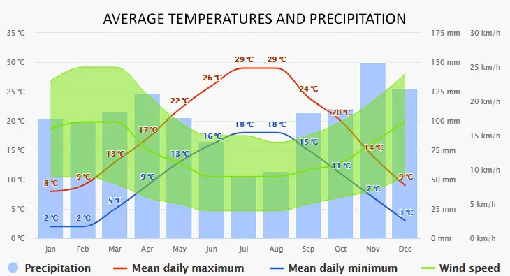
The climate diagrams are based on 30 years of hourly weather model simulations. They give good indications of typical climate patterns and expected conditions (temperature, precipitation, sunshine, and wind). The “mean daily maximum” (solid red line) shows the maximum temperature of an average day for every month for Pag. Likewise, the “mean daily minimum” (solid blue line) shows the average minimum temperature.
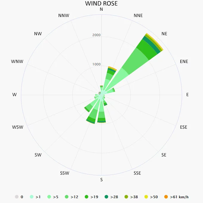
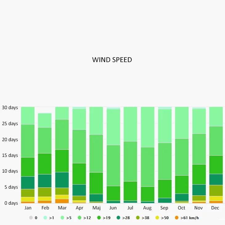
The wind rose for Pag shows how many hours per year the wind blows from the indicated direction. The diagram for Pag shows the days per month, during which the wind reaches a certain speed.
Day 1. Novalja – Rab 26, 41 km (16, 41 nm), Day 2. Rab – Krk 38, 64 km (24, 01 nm), Day 3. Krk – Rijeka 43, 85 km (27, 25 nm), Day 4. Rijeka – Rabac 36, 36 km (22, 59 nm), Day 5. Rabac – Pula 65, 13 km (40, 47 nm), Day 6. Pula – Mali Losinj 72, 26 km (44, 90 nm), Day 7. Mali Losinj – Ilovik – Novalja 14, 76 km (9, 17 nm) – 29, 07 km (18, 06 nm)
Day 1. Novalja – Mali Losinj 34, 78 km (21, 61 nm). Day 2. Mali Losinj – Veli Rat (Dugi Otok) 62, 95 km (39, 12 nm). Day 3. Veli Rat – Sali (Dugi Otok) 43, 42 km (26, 98 nm). Day 4. Sali – Zadar 23, 90 km (14, 85 nm). Day 5. Zadar – Pag 62, 79 km (39, 02 nm). Day 6. Pag – Rab 48, 17 km (29, 93 nm). Day 7. Rab – Lun – Opatija 8.24 km (5.12 nm)
If you trust a specialist to find the ideal boat for you, or if you can’t find a suitable yacht, find us on one of our contact details, or fill out the form below. After submitting your request, we will contact you within 24 hours to answer your questions and provide solutions to your carefree journey. We will help you to find the best solution.
Excellent
"If you rented a boat from us, we don't need to introduce ourselves. If you book with us for the first time, you will soon get to know us." 🙂 Some feedback about us...
27/05/2017
Lavrion - Greece
Sehr guter Service und Beratung. Die Buchung war recht einfach.
Family Doppler (Germany)
28/05/2022
Milos - Greece
Our catamaran sailing trip was fantastic. The Alegria is an amazing boat. Comfortable and beautiful, with all the features one could hope for...
Harry (USA)
13/08/2022
Dubrovnik - Croatia
Ismét nagyon jó áron kaptunk,egy igazán luxus hajót. A Bali 4.5 egy igazán jó válaasztás. A Köszönjük az ügyintézést.
Ágnes (Hungary)
03/06/2023
Mykonos - Greece
Easy to book, and perfect communication from the very beginning. The boat was in perfect condition and very comfortable for a group of 10pax...