Are you planning a sailing trip in Eleuthera? Eleuthera is the fourth-largest island on the Bahamas. The chain of islands is among the most significant and iconic parts of the region with its countless pineapple fields and beaches covered with pink sand. Its eastern coast faces the Atlantic Ocean and the western coast is opposite the Great Bahama Bank. The island is very narrow and long at the same time; it is 4-kilometre-wide on average and has a length of 180 kilometres. It has marvellous beaches and is surrounded by crystal clear turquoise and blue waters. Its name means ‘freedom’ in Greek. Let us explore and experience this freedom! This article will be the most useful read for those who want a comprehensive but friendly guide to the weather, routes, ports and attractions in Eleuthera.

This article gives you an overview of the following topics:
- Ports and islands around Eleuthera
- The-weather of Eleuthera
- Sail in Eleuthera! Eleuthera sailing adventures
- Sailing in Eleuthera : a week sailing itinerary
- 7 Days Eleuthera sailing adventure (longer)
- Marine gas near Eleuthera
Ports and islands around Eleuthera
Eleuthera offers a wide range of harbors and anchorages, with more than twenty suitable spots for anchoring and over a dozen docking locations available for sailors. However, navigating around the island can be challenging. Many areas have shallow waters, numerous reefs complicate passage, and tidal changes can be significant. The scenery is stunning, and the locals are exceptionally welcoming. Rent a boat in Eleuthera and let the island’s exploration become a true adventure. As a sailor, prepare in advance, check charts for reefs and shallow zones, as accurate navigation is essential.

Spanish Wells
Spanish Wells is located on St. Georges Cay, west of the northern tip of Eleuthera. Its harbor lies along a long channel bordered by two small islands. The area is well protected, though easterly winds can occasionally affect anchored boats, so using a reliable anchor is recommended. On the western side, the hurricane hole offers excellent shelter in bad weather, with mangrove tie-offs providing exceptional stability. The mooring balls on the eastern side offer safe, simple stopping points, especially if you only plan a short visit to the Spanish Wells Yacht Haven & Marina. From here, the town center is within walking distance, ideal for provisioning and restocking. Royal Island Harbour on the western side is suitable for deeper-draft vessels, though it lacks infrastructure, so ensure you have all necessary supplies on board.
Governor’s Harbour
Governor’s Harbour, located in the center of Eleuthera, is one of the island’s most popular boating destinations. The anchorage off Cupid’s Cay is usually calm, with water depths between three and four meters, making it ideal for most charter boats. The seabed holds well, making it reliable even for longer stays. Westerly winds may pose occasional challenges, so choose a position where your bow faces the wind. French Leave Marina is a well-equipped facility offering electricity and freshwater, with slips for both megayachts and smaller vessels. The town provides easy access to shops, restaurants, and services, and the annual summer regatta is a must-see event for sailors and spectators alike. 
Palmetto Point
The Palmetto Point area is peaceful and ideal for sailors seeking calm waters and convenient anchorage. Pau Pau Bay offers excellent holding, thanks to its stable sandy seabed. If southerly or southeasterly winds are expected, choose a more sheltered inner position to avoid swell. Runaway Bay Marina is a comfortable option for dockage and resupplying. Its three-meter-deep entrance channel accommodates medium-draft vessels. The area features restaurants, shops, and great onshore activities, making it perfect for a relaxing layover.
Rock Sound
Rock Sound is one of the friendliest harbors on the island, with great opportunities to restock provisions or perform minor maintenance. Most anchorage spots hold well, though none are completely protected, so pay attention to anchor security and tidal changes during windy periods. Two free dinghy docks near Wild Orchid make going ashore especially convenient. Davis Harbour Marina offers modern facilities including freshwater, fuel, showers, laundry, ice, and repair services. For an extended stay in southern Eleuthera, this is one of the best-equipped options.
Harbour Island
Harbour Island is a favorite among charter sailors thanks to its scenic caves and unique pink sand beaches. Coastal waters are clear but shallow in some areas, so monitor charts and buoys carefully. The two main marinas, Harbour Island Club & Marina and Valentines Marina, offer high-quality services. Fuel, showers, restaurants, and bars are all available, making them ideal for multi-day stays or a touch of luxury during your journey.
Hatchet Bay
Hatchet Bay is one of the safest and most sheltered anchorages in Eleuthera. Although the entrance appears narrow at first glance, it is wide enough for most charter vessels and offers adequate depth. Thanks to the natural protection, the bay is secure in nearly all wind directions, making it an excellent refuge in rough weather. Anchoring is free, with the best spots located on the northwest side. Near Alice Town, you’ll find dinghy docks, grocery stores, restaurants, and marine services, making it a convenient place to resupply or perform minor maintenance on your vessel. Eleuthera boat rentals
The weather of Eleuthera
Eleuthera has a subtropical climate, characterised by moderate warm weather during the entire year. The average annual temperature is 28° Celsius; this means 21° Celsius in the winter and 27° Celsius in the summer. The temperature rarely drops below 16° Celsius or above 32° Celsius. The dominant wind blows from the northeast in the winter and from the southeast in the summer, freshening up the air a bit. The velocity of the wind is an average of 8.1 nm/h during the entire year. Most of the precipitation falls in the summer months. At the end of the summer – during the period between June and November – tropical cyclones (hurricanes) may be a threat. The strong wind (with a blast of over 48.6 nm/h) and the seawater that rises, as a result, may cause heavy damage. The weather is usually pleasant in Eleuthera during the whole year, meaning that sailing is also enjoyable in all seasons. We should definitely avoid the hurricane season though, as storms may be very challenging. Check the sailing conditions and wind rose diagram of Eleuthera
Sail in Eleuthera! Eleuthera sailing adventures
Sailing in Eleuthera: a week sailing itinerary
On this route, we leave from the beautiful Harbour Island in the northern corner of Eleuthera. Then we navigate towards the south, and after passing by all-important port towns of the island, we sail to Nassau. We stop at Highbourne Cay so that we can prepare for the longest day of the week. After Nassau, we make two more stops at two islands which are located directly next to Eleuthera.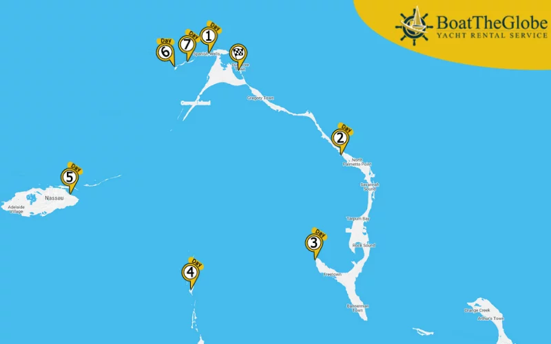
Day 1. Harbour Island – Spanish Wells
10.2 nm
Before sailing to Spanish Wells, it is recommended to study the route in advance. The channel leading to the bay is quite narrow, and the course is marked by white buoys; we should leave it to the starboard when navigating through. Inside the channel, we should also be careful about the other vessels when reaching town. Most anchorages are fairly small. In Spanish Wells Yacht Haven, they accommodate 30 boats, and the maximum depth of water here is 3.5 metres. We can replenish our ice and water supplies here, and they also have electricity, a restaurant and a bar. Read more about what to do in Eleuthera or Eleuthera boat rentals
Day 2. Spanish Wells – Governor’s Harbour
41.6 nm
We can choose from several moorings at Governor’s Harbour. The best ones can be found near the dock Club Med and northwest of the town centre. These provide great protection from the northern winds. The mooring buoys in the area are unmarked – we should contact the port authority about using them via channel VHF 16.
Day 3. Governor’s Harbour – Cape Eleuthera
21.9 nm
Cape Eleuthera is among the favourite spots of Bahamian fishermen and is a major destination for sea enthusiasts. It is located between Exuma Sound and Rock Sound. There is a full-service yacht marina here that has received a certificate thanks to its strict environmental practices. They have a lot of moorings for all types of vessels, and they also provide shower cabins, laundry service and free Wi-Fi. We can get water, ice and refuel our boat here, and they also have boat maintenance, a grocery store and a restaurant. One of the most beautiful beaches in the are can be found nearby; it is ideal for both swimming and scuba-diving.
Day 4. Cape Eleuthera – Highbourne Cay
26.8 nm
Highbourne Cay is a relatively small privately-owned island between Nassau and Eleuthera. It is a favourable stop among skippers heading to Nassau. Here we can replenish our water and ice supplies, refuel our boat, and buy groceries and all the essentials we might need. The port is beautiful, well-maintained and protected.
Day 5. Highbourne Cay – Nassau
33.1 nm
Nassau – the largest town and capital of the Bahamas – can be found on a smaller island called New Providence. There are some fantastic marinas offering several opportunities for spending some pleasant quality time here. Nassau Yacht Haven and Harbour View Marina are the two largest yacht marinas in town. Nassau Yacht Haven is an establishment with protected docks, providing 135 berths and full service. The depth of water is 5.5 metres. Harbour View Marina is a safe and convenient port with access to fuel and electricity. They can accommodate 43 boats, and they have shower cabins, a restaurant and a bar as well. Elizabeth on Bay Marina and Old Bahama Bay are two smaller docks in the area.

Day 6. Nassau – Egg Island
33.6 nm
Egg Island is a tiny island with a territory of 800 square kilometres, located west of the northern corner of Eleuthera. The island is surrounded by a crescent-shaped beach. The best anchorages are on the western side; they are protected by an extensive coral reef. We should arrive as early as possible, in daylight, so that we can find the passage between the port and the beach easily. The shipwreck of the Arimora cargo ship is located directly next to the island. It is a very exciting scuba-diving spot, as large groups of fish have colonised the remains of the ship.
Day 7. Egg Island – Royal Island – Harbour Island
17.6 nm
Royal Island is a privately owned island with a territory of 430 hectares, located at the northern corner of Eleuthera. There are marvellous white sandy beaches here, providing an amazing view of the ocean. The island is very peaceful. We need to request permission from the coast guard to anchor and disembark. It is a perfect spot for the last night of our trip.
7 Days Eleuthera sailing adventure (longer)
This route is very similar to the previous one for many reasons, but we have to do greater distances every day. We will pass by many of the islands belonging to Exuma Cays between Eleuthera and Nassau, so we will have the opportunity to explore this wonderful area. This route is very popular among sailors arriving in the Bahamas.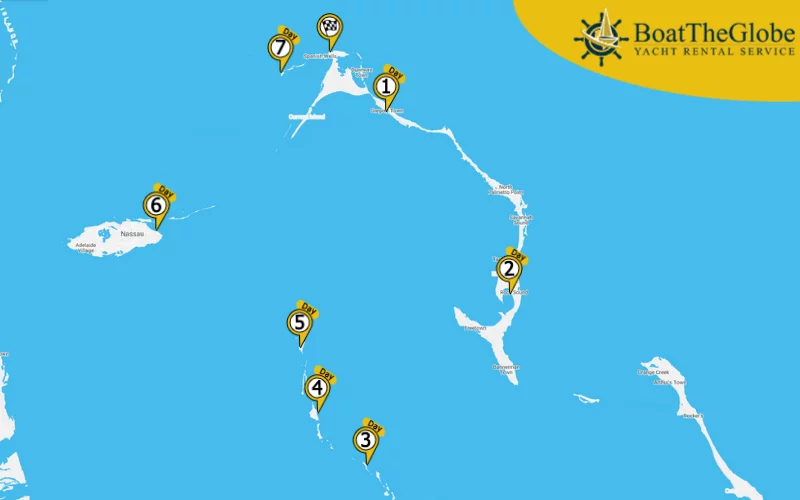
Day 1: Spanish Wells – Annie Bight (21.3 nm – Sailing time*: about 3.5 hours), Day 2: Annie Bight – Rock Sound (41 nm – Sailing time*: about 6.5 hours), Day 3: Rock Sound – Waderick Wells Cay (39.2 nm – Sailing time*: about 6.5 hours), Day 4: Waderick Wells Cay – Shroud Cay (16.1 nm – Sailing time*: about 2.5 hours), Day 5: Shroud Cay – Highbourne Cay (12.9 nm – Sailing time*: about 2 hours), Day 6: Highbourne Cay – Nassau (34.1 nm – Sailing time*: about 5.5 hours), Day 7: Nassau – Egg Island – Spanish Wells (36.2 nm – Sailing time*: about 6 hours)
* – an average 43 ft sailing yacht, with average weather conditions, sails around 6-7 knots per hour.
Marine gas near Eleuthera
- SPANISH WELLS MARINE & HARDWARE: , 8-12 & 13-17 , GPS Coordinates: 25.542075, -76.751341
- RUNWAY BAY MARINA: , GPS Coordinates: 25.144444, -76.169167
- CAPE ELEUTHERA RESORT AND MARINA: Depth: 2 m, GPS Coordinates: 24.836154, -76.343758
- HIGHBOURNE CAY MARINA: Depth: 2, 5 m, Working time: 8-17, GPS Coordinates: 24.708938, -76.821578
- HARBOUR VIEW MARINA, NASSAU: Depth: 2 m, GPS Coordinates: 25.074623, -77.312880
- HARBOUR ISLAND CLUB AND MARINA: Depth: 3 m, Working time:8-18, GPS Coordinates: 44.8749, 13.84651
- FRENCH LEAVE HARBOUR VILLAGE MARINA: Depth: 2, 5 m, GPS Coordinates: 25.203069, -76.246944
Eleuthera is a wonderful island; visitors can admire breathtaking, secluded bays, dramatic rocky areas and marvellous beaches here. All the beaches provide an amazing panorama, and thanks to the great ports, the area is perfect for an unforgettable sailing trip. Find Bahamas sailing routes, catamaran rental Bahamas, last-minute yacht charter Bahamas, sailing holidays Bahamas skippered, bareboat catamaran charter Bahamas, Bahamas sailing yacht charter bareboat, crewed yacht charter Bahamas, bareboat yacht charter Bahamas, Bahamas luxury yacht charter, yacht rental Bahamas, catamaran charter Bahamas, sailboat charter Bahamas, motor yacht charter Bahamas
HELP ME TO CHOOSE THE PERFECT BOAT