The Bahamas is a standout yacht charter destination for sailors who want shallow turquoise water, island-hopping routes and beautiful anchorages in a true tropical setting. The main attraction is the freedom to move between cays, beaches and marinas, but the shallow banks, coral reefs, tides and longer crossings require careful route planning. This guide helps you choose whether Abaco, the Exumas, Eleuthera or Grand Bahama and Bimini best match your crew’s experience level and preferred sailing rhythm.

The main points are the following:
- Which month is the best for sailing in the Bahamas?
- Where is the best place to sail in the Bahamas? – ports and islands
- Sail in the Bahamas! Bahamas sailing routes and catamaran tours
Which month is the best for sailing in the Bahamas?
The best sailing season in the Bahamas runs from December to April. During these months, steady trade winds, warm but comfortable temperatures, and exceptionally clear sea conditions create ideal yacht charter weather. This is when the Bahamas reveal their most spectacular side, with turquoise shallows, vibrant coral reefs, and endless island-hopping opportunities that make the region one of the world’s finest winter sailing destinations.
Spring: Spring is one of the most balanced and enjoyable sailing seasons in the Bahamas. Between March and May, daytime temperatures usually range from 25–29°C, while sea temperatures climb to a pleasant 24–26°C. Northeasterly trade winds remain consistent, commonly blowing between 12–18 knots, creating perfect conditions for longer passages between islands. The sea becomes calmer than in winter, underwater visibility is outstanding, and destinations such as the Exumas and the Abacos look almost unreal with their crystal-clear turquoise waters. Marinas and anchorages still feel lively, but after Easter the overall atmosphere becomes noticeably more relaxed.
Summer: Summer in the Bahamas is hot, tropical, and far more humid. From June through August, air temperatures frequently reach 30–33°C, while sea temperatures can rise to 29–30°C. Winds become lighter and less predictable, often remaining between 8–14 knots, which means motor sailing is more common. The shallow sandbanks and lagoons glow in spectacular shades of turquoise during this season, although afternoon showers and thunderstorms become more frequent. Hurricane season officially begins in June, so experienced sailors closely monitor weather forecasts and tropical systems. One major advantage of summer sailing is the quieter atmosphere, with many famous anchorages and marinas feeling far less crowded.
Autumn: Autumn is a transitional and constantly changing season across the Bahamas. September and October remain part of hurricane season, bringing higher humidity and sea temperatures around 29°C. By November, however, weather conditions become noticeably more stable. Temperatures drop back to around 26–28°C, trade winds strengthen again, and sailing conditions improve significantly. Charter activity gradually returns while marinas are still not operating at peak capacity. The softer autumn light and quieter islands give Bahamian sailing a particularly exclusive and relaxed atmosphere during this period.
Winter: Winter is the classic peak charter season in the Bahamas, attracting sailors from North America and Europe seeking warm-weather cruising. From December through February, daytime temperatures generally stay between 23–26°C, evenings feel fresher, and sea temperatures remain around 23–25°C. Northeasterly winds are steady and energetic, often blowing at 15–22 knots, creating highly enjoyable sailing conditions. Occasional cold fronts moving down from Florida can temporarily bring rougher seas and stronger winds, especially on exposed passages. Marinas around Nassau and popular anchorages throughout the Exuma chain become significantly busier, yet the combination of brilliant winter sunshine, stable trade winds, and glowing turquoise waters delivers the most iconic Bahamas yacht charter experience.
The best coasts and ports in the Bahamas
The Bahamas offers several excellent islands and harbours that are perfect for sailors. The archipelago is divided into 5 large archipelagos. Rent a boat in Bahamas and enjoy complete tranquility as you glide from one beautiful bay to another. Their brief characteristics:
- Nassau (New Providence Island) – Sailing in Nassau is the convenience of the capital, with its busy harbours and easy access to nearby islands. yacht charter Nassau
- Exumas – Exumas sailing is a world of crystal clear waters, sheltered harbours and countless cays. Exumas boat rental
- Abacos – Abacos sailing offers calm, sheltered waters with well-equipped marinas in Marsh Harbor and Hope Town. Abacos yacht charter
- Bimini – The closest point of the islands to the United States, with great fishing and diving opportunities.
- Harbor Island – Sailing in Eleuthera is a luxurious, relaxed destination with pink sand beaches and yacht-friendly marinas. Eleuthera boat rentals

Main ports of the islands
- Port of Nassau (Nassau) – The capital’s primary port, near the old town and Paradise Island, also receives cruise ships. In addition to the luxury standard, the level of everyday services is also the highest here in the entire Caribbean region.
- Bay Street Marina (Nassau) – Modern marina with excellent facilities for yachts, close to the city center.
- George Town (Exumas) – The main hub of the Exumas, offering a wide range of services and a vibrant boating community that can accommodate more than 400 yachts. It is famous for the annual Exuma Regatta, which attracts sailors from all over the world. The city itself has a friendly, relaxed atmosphere, with beaches and restaurants.
- Staniel Cay Yacht Club (Exumas) – This smaller but popular stop with a full-service marina and access to nearby attractions. The island abounds with tourist attractions. Here you can see, for example, the strange and unique swimming pigs.
- Marsh Harbor (Abacos) – Abaco’s largest port, well-equipped and offering many services.
- Hope Town (Abacos) – With its picturesque lighthouse, Hope Town has a charming harbour and sheltered anchorages.
- Alice Town (Bimini) – A small but main port for those coming to Bimini, close to local attractions.
- Resorts World Bimini Marina (Bimini) – A popular stop for luxury yachts with resort services and a casino.
- Governor’s Harbor (Eleuthera) – Key harbour close to charming towns and beaches.
- Harbor Island (Eleuthera) – Known for its harbor and the island’s pink sand beaches and luxury. Nearby is the picturesque town of Dunmore. This settlement used to be the capital of the Bahamas.
How to choose your Bahamas sailing area?
- If you are sailing in the Bahamas for the first time: Choose the Abaco area, as it has more sheltered waters and many escape options – navigation is learnable, but don’t plan on days with 40-60 nm.
- If you are looking for a “postcard Bahamas” experience: The Exumas are the most spectacular, but due to narrow passages and currents, it is recommended for advanced sailors or with a skipper.
- If you want active sailing with longer stages: Eleuthera is a good choice, as it offers a variety of stops, but there are more open, “thready” sections.
- If you want a mixed week (crossing + relaxation): The Grand Bahama/Bimini route is good, but the crossings require a stable weather window and Plan B ports.
- If you go in winter (Dec-Feb): expect cold fronts and rougher open water – plan for shorter days, daytime arrivals, and a flexible itinerary.
Sail in the Bahamas! Bahamas sailing routes and catamaran tours
Sailing vacations in the Bahamas: A week catamaran sailing trip around the Abaco Islands
A calmer, “island hopping” trip with lots of coastal stops. More sheltered waters, lots of stops and classic “island hopping” – good if you want a relaxed week and like short maneuvers. Watch out: the current plan includes several 60+ nm days, it is worth splitting this (early departure, plan B ports). Recommended level: beginner-intermediate Open sea sections: no

Day 1: Marsh Harbour – Little Harbour (13.3 nm – Sailing time*: about 3 hours)
We are leaving Marsh Harbour of the Abaco Beach Resort which is a large holiday resort with a huge harbour. In addition, it is the region’s largest harbour accepting bigger yachts. Sailing to Little Harbour is really a light trip, and at the end, we arrive at a marvellous white sandy beach.
Day 2: Little Harbour – Abaco National Park – Sandy Point (52.4 nm – Sailing time*: about 9 hours)
Leaving Little Harbour, we sail in the direction of Sandy Point. However, we make a short detour to Abaco National Park. Founded in 1994, the park covers 20.500 hectares, and is home to many protected parrot species. Sandy Point is a picturesque little town, nestled in the shade of coconut palms. It is hard to decide whether the white sandy beach, the colourful houses and lush gardens offer a more beautiful view. One thing is for sure. If you are looking for some peace and quiet, Sandy Point is the perfect holiday destination for you.
Day 3: Sandy Point – Wood Cay – Great Abaco (25.9 nm – Sailing time*: about 4 hours)
You can spend a quiet and peaceful day at Wood Cay. Locals are famous for their hospitality. They are happy to welcome you into their daily lives. They mainly work in the fishing industry. You should definitely go on a boat trip with locals. After fishing, you will prepare the fish together and have a nice meal. You would rather go to a restaurant? There are only a few places to choose from and they look pretty rustic, but give them a try! You will be offered high-quality fresh seafood dishes.
Day 4: Great Abaco – Big Joe Downer Cay -Little Joe Downer Cay – South Riding Point (52.2 nm – Sailing time*: about 9 hours)
Our next stop is perfect if you have to refuel. South Riding Point is famous for having one of the largest oil and fuel storage terminals in the region. Although, Hurricane Dorian damaged the terminal in 2019, and reconstruction work is still ongoing. South Riding Point is an interesting stop during your journey.
Day 5: South Riding Point – Nunjack Cay – Green Turtle Cay (55.8 nm – Sailing time*: about 9 hours)
Depending on the weather you can choose from two high-standard docking opportunities. Rat Cay on the south, for example, is a great place for nature and watersport lovers. Meanwhile, the northern valley is merely chosen by couples for watching a romantic sunset. Green Turtle Cay boasts of its popular beaches, accommodation and picturesque ports. Need for repair on your yacht? Don’t worry, there are experienced repairmen to fulfil your needs. Until the reparation goes on, try a delicious meal from lobster in a local restaurant.
Day 6: Green Turtle Cay – Treasure Cay – Man-O-War Cay / Guana Cay (15.4 nm – Sailing time*: about 3 hours)
Take the chance and lay your mattress on the beach which is regarded as one of the world’s top 10 beaches. Before continuing your voyage take a walk and enjoy the fascinating view. Man-O-War Cay, a historic yacht-building island, which is located north Treasure Cay is just a short ferry ride. Many generations of the famous yacht-builder Albury family used to live and work here. The next stop on your trip could be the Bakers Bay Resort & Marina on Guana Cay. As you would expect, it is a well-equipped marina with 158 berths for yachts. Let’s do some sports on the island either on the golf court or in the water with other divers and snorkellers.
Day 7: Guana Cay – Pelican Cay Land & Sea Park – Elbow Cay – Marsh Harbour (28.9 nm – Sailing time*: about 5 hours)
Move ahead to Pelican Cay Land & Sea Park. This is, in fact, a 2100-acre nature reserve; one of the world’s most wonderful and unique marine habitats with special coral reefs, flora and fauna. Besides, another great programme for this day is to get on shore at Elbow Cay which is 3.5 nm from the Marsh Harbour. It is well-known for its 37 m tall red and white striped lighthouse called Hopetown Lighthouse which was built-in 1863. On the top you can marvel at the stunning, magnificent sea. A full day is needed for a trip to explore this 7.0 nm long tiny island. Beyond the beautiful nature mouth-watering food, delicious beverages and recreational beaches await you. What else awaits you beyond the beautiful nature? Mouth-watering food, delicious beverages and recreational beaches.
* – an average 43 ft sailing yacht, with average weather conditions, sails around 6-7 knots per hour.
Public marinas around Abaco Island:
- Abaco Beach Resort Marina – GPS Coordinates: 26.545434, -77.045303
- Conch Inn Marina – GPS Coordinates: 26.546197, -77.053189
- Great Abaco Beach Resort Marina – GPS Coordinates: 26.545568, -77.045260
- Green Turtle Cay: Bluff House Beach Resort & Marina – GPS Coordinates: 26.776301, -77.340583
- Green Turtle Cay: Sunset Marine – GPS Coordinates: 26.765626, -77.327796
- Jib Room Marina – GPS Coordinates: 26.546208, -77.053198
- Sandy Point: Lightbourn’s Marina – GPS Coordinates: 26.025612, -77.401478
- Mangoes Marina – GPS Coordinates: 26.546687, -77.052472
- El Cow Bay: Lower Public Dock – GPS Coordinates: 26.540836, -76.959752
- Spanish Cay Marina – GPS Coordinates: 26.941254, -77.526883
- Treasure Cay Beach, Marina & Golf Resort – GPS Coordinates: 26.674505, -77.280976
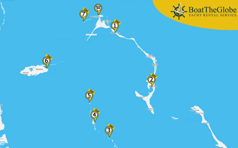
Nassau sailing: sailing around the Exumas islands – for experienced sailors
The “essence of the Bahamas” in terms of scenery and experience, but requires routine due to strong currents, narrow passages and precise anchoring; it is not awkward to go with a captain here. Recommended level: advanced Open sea sections: yes

Day 1: Nassau (Palm Cay / ONE Marina) – Highbourne Cay (Highbourne Cay Marina) (30.9 nm – Sailing time*: about 5 hours)
Leaving Paradise Island the first destination is the Exumas. This island group looks like a pearl necklace. We can find here several ports and sheltered beaches. On one of its tiny islands protected iguana species hide among the gorgeous cliffs.
Day 2: Highbourne Cay – Bells Cay and its surrounding – Compass Cay (32.0 nm – Sailing time*: about 5 hours)
It contains the tiny islands of the nature reserves of Exuma Cays Land and Sea Park. The main attraction for snorkellers is the Rocky Dundas caves on Little Bells Cay.
Day 3: Compass Cay – Staniel Cay – Great Guana Cay – Safe Harbor Marina (25.9 nm – Sailing time*: about 4 hours)
Staniel Cay is the tourist centre of the Exumas. Friendly inhabitants, clear water and small calm beaches are the typical features of this island. You may have heard about it as a great place for deep-sea fishing. It is worldwide known as the scenery of the James Bond films. Do not miss Thunderball Grotto, the most outstanding place for snorkelling in the Bahamas. Moreover, visiting the Staniel Cay New Year’s Cruising Regatta is also a must that is organized by the Staniel Cay Yacht Club annually on 31 December. There is a yacht competition with traditional local sloop sailing yachts. All in all, it can be an unforgettable experience for everybody.
The Great Guana Cay’s beach is the longest in the Bahamas, about 5, 5miles.
Day 4: Safe Harbor Marina – Emerald Bay Marina (26.9 nm – Sailing time*: about 5 hours)
After berthing at Emerald Bay, you can choose from many entertainment options. There are larger hotel complexes, a golf course, bars restaurants and several shops. Extra tip: rent a squad for the day and discover the opportunities the town has to offer!
Day 5: Emerald Bay Marina – Farmer’s Cay (Little Farmer’s Cay Yacht Club) (29.5 nm – Sailing time*: about 5 hours)
Little Farmer’s Cay is a small island, located between Great Guana Cay and Great Farmer’s Cay. Its port, Little Harbour, is well-protected. It is perfect for berthing. You can find Farmer’s Cay Yacht Club here. The wildlife at Farmer’s Cay is truly amazing. It is home to exotic birds, sea turtles, dolphins, sharks and tropical fish. There are deep-sea caves and coral reefs nearby. They are perfect for diving and snorkelling. You have to go swim with the turtles!
Day 6: Farmer’s Cay – Warderick Wells Cay – Shroud Cay (dock at Highbourne Cay) (52.9 nm – Sailing time*: about 9 hours)
A visit to the tourist centre of the nature reserve can make our day very special. The park was the first land and sea park in the world. Still, today is one of the most successful marine parks. Scuba diving and snorkelling are very popular here. You can encounter nature first-hand by feeding the endangered Bahamian iguanas or catching a glimpse of the elusive hutia.
Shroud Cay is a small unpopulated island, an Eden with diverse flora and fauna. It is only accessible by yacht, and animal-watching tours are organized for on-foot tourists.
Day 7: Highbourne Cay – The wonderful Atlantis – Nassau (39.2 nm – Sailing time*: about 7 hours)
Finally, let’s have luxury and glitter. A huge entertainment facility with a big casino, excellent clubs and restaurants, amazing aquariums and a unique aquapark are waiting for you. As you would expect, the port is protected by security guards; and besides smaller boats, there are 63 berths for mega-yachts.
* – an average 43 ft sailing yacht, with average weather conditions, sails around 6-7 knots per hour.
Public marinas around Exumas:
- Paradise Island Ferry Terminal – GPS Coordinates: 25.079938, -77.321459
- Hurricane Hole Marina – GPS Coordinates: 25.080025, -77.319925
- Ocean Club Marina – GPS Coordinates: 25.078917, -77.303810
- Nassau Harbour Club – GPS Coordinates: 25.074570, -77.313092
- Nassau Yacht Haven Marina – GPS Coordinates: 25.074930, -77.317791
- Lyford Cay Club Marina – GPS Coordinates: 25.036386, -77.514627
- Palm Cay / ONE Marina – GPS Coordinates: 25.020405, -77.273897
- Staniel Cay Yacht Club- GPS Coordinates: 24.172750, -76.445132
- Compass Cay – GPS Coordinates: 24.261054, -76.512952
- Safe Harbor Marina – GPS Coordinates: 23.907774, -76.272456
- Highbourne Cay Marina – GPS Coordinates: 24.709507, -76.822518
- Little Farmer’s Cay Yacht Club – GPS Coordinates: 23.964031, -76.323325
- Emerald Bay Marina – GPS Coordinates: 23.630349, -75.917039
- Exuma docking services – GPS Coordinates: 23.503911, -75.767587
- Barreterre Dock – GPS Coordinates: 23.698345, -76.040074
1 week Eleuthera sailing adventure
Works with longer daily distances, with many “crossing” characters – this is good if you are an active sailor and can handle a more strenuous ride, but the stops are varied. Recommended Level: Intermediate Open Water Stages: Yes
Day 1: Spanish Wells – Annie Bight (21.3 nm – Sailing time*: about 3.5 hours), Day 2: Annie Bight – Rock Sound (41 nm – Sailing time*: about 6.5 hours), Day 3: Rock Sound – Waderick Wells Cay (39.2 nm – Sailing time*: about 6.5 hours), Day 4: Waderick Wells Cay – Shroud Cay (16.1 nm – Sailing time*: about 2.5 hours), Day 5: Shroud Cay – Highbourne Cay (12.9 nm – Sailing time*: about 2 hours), Day 6: Highbourne Cay – Nassau (34.1 nm – Sailing time*: about 5.5 hours), Day 7: Nassau – Egg Island – Spanish Wells (36.2 nm – Sailing time*: about 6 hours)
* – an average 43 ft sailing yacht, with average weather conditions, sails around 6-7 knots per hour.
Public marinas around Eleuthera:
- SPANISH WELLS MARINE & HARDWARE: , 8-12 & 13-17 , GPS Coordinates: 25.542075, -76.751341
- RUNWAY BAY MARINA: , GPS Coordinates: 25.144444, -76.169167
- CAPE ELEUTHERA RESORT AND MARINA: Depth: 2 m, GPS Coordinates: 24.836154, -76.343758
- HIGHBOURNE CAY MARINA: Depth: 2, 5 m, Working time: 8-17, GPS Coordinates: 24.708938, -76.821578
- HARBOUR VIEW MARINA, NASSAU: Depth: 2 m, GPS Coordinates: 25.074623, -77.312880
- HARBOUR ISLAND CLUB AND MARINA: Depth: 3 m, Working time:8-18, GPS Coordinates: 25.49, -76.63
- FRENCH LEAVE HARBOUR VILLAGE MARINA: Depth: 2, 5 m, GPS Coordinates: 25.203069, -76.246944
More Eleuthera sailing adventures
7 Days Bimini sailing route(longer)
The first half brings faster and more open water crossings (time window is important!), the second half is a more relaxed exploration around Bimini – a good “mixed” program. Recommended Level: Intermediate Open Water Stages: Yes
Day 1: South Bimini, Bimini Sands Marina – Bimini, Bimini Big Game Club (1.1 nm – Sailing time*: about 30 minutes), Day 2: North Bimini – Port Lucaya, Grand Bahama (61 nm – Sailing time*: about 9.5 hours), Day 3: Port Lucaya – Old Bahama Bay (25.8 nm – Sailing time*: about 4 hours), Day 4: Old Bahama Bay – Blue Water Marina, North Bimini (62.2 nm – Sailing time*: about 10 hours), Day 5: North Bimini – North Cat Cay (11 nm – Sailing time*: about 2 hours), Day 6: North Cat Cay – Gun Cay (2.2 nm – Sailing time*: about 30 minutes), Day 7: Gun Cay – South Bimini (7.5 nm – Sailing time*: about 1.5 hours)
* – an average 43 ft sailing yacht, with average weather conditions, sails around 6-7 knots per hour.")
Public marinas around Bimini:
- BIMINI SANDS MARINA: Depth: 2.5 m , GPS Coordinates: 25.709361, -79.299608
- BLUE WATER MARINA: Depth: 3 m, Working time: 10-15, GPS Coordinates : 25.724865, -79.298217
- CAT CAY MARINA: Depth: 3 m, GPS Coordinates: 25.554400, -79.275003
- LIGHTHOUSE YACHT CLUB AND MARINA: GPS Coordinates: 24.725000, -77.805000
- CHUB CAY MARINA: Depth: 3.5 m, GPS Coordinates: 25.410965, -77.902506
- PORT LUCAYA MARINA: Depth: 3 m, GPS Coordinates: 26.513939, -78.642033
- OLD BAHAMA BAY: GPS Coordinates: 26.703150, -78.997867
How to choose a Bahamas sailing itinerary?
- If you sail in the Bahamas for the first time: choose Abaco because it gives more protected waters, more stop options and an easier daily rhythm.
- If you want the most iconic turquoise-water experience: choose the Exumas because they deliver the strongest reef, sandbank and island-hopping character.
- If you want active sailing and longer daily legs: choose Eleuthera because it offers a varied route with more exposed sections.
- If you want crossings combined with relaxed island days: choose Grand Bahama and Bimini because this route gives a faster start and an easier finish.
Sailing in the Bahamas FAQ
What makes sailing in the Bahamas different from other Caribbean cruising regions?
Bahamas sailing is shaped by shallow banks, extensive island chains, clear water visibility and a navigation environment where tidal influence often matters more than many first-time visitors expect. Unlike some Caribbean destinations dominated by mountainous islands and longer passages, many Bahamian routes combine relatively short island hopping legs, protected waters and flexible anchoring opportunities that influence yacht choice and itinerary design.
How do trade winds influence sailing routes in the Bahamas?
Trade winds play a major role in route planning, passage comfort and daily sailing distance throughout much of the year. Wind direction and strength affect anchorage exposure, sea state and preferred travel direction between islands. Understanding how prevailing winds interact with shallow banks and open-water crossings helps sailors create more efficient itineraries and improve route risk awareness.
Is the Bahamas suitable for beginner sailors?
Many parts of the Bahamas are considered accessible for beginners because of relatively short sailing distances, numerous anchorages and large areas of protected waters. However, navigation difficulty should not be underestimated. Shallow depths, tidal influence, coral hazards and weather variability require careful route planning, accurate chart use and prudent decision-making, particularly for first-time charter guests.
When is the best time to sail in the Bahamas?
The best months are typically influenced by weather seasonality, trade-wind consistency and personal travel preferences. Winter sailing is popular because of comfortable temperatures and reliable cruising conditions, while shoulder season periods may offer lower crowd levels and increased flexibility. Seasonal suitability should also consider hurricane season, charter demand and the desired balance between weather stability and marina availability.
How does hurricane season affect yacht charter planning in the Bahamas?
Hurricane season is an important planning factor because it can influence weather predictability, insurance requirements and itinerary flexibility. While sailing remains possible during some periods, route planning logic often becomes more weather-dependent. Crews should monitor forecasts closely, maintain contingency plans and understand how seasonal conditions can affect navigation context, marina operations and overall cruising strategy.
Which yacht type works best for exploring the Bahamas?
Yacht suitability depends heavily on route characteristics and water depth. Catamaran charter is often popular because shallow draft can provide access to anchorages and cruising areas that may be less practical for deeper-draft yachts. Sailboat charter, motor yacht charter and crewed yacht charter options can also work well depending on passage length, onboard comfort expectations, yacht handling preferences and itinerary objectives.
How long should a Bahamas sailing itinerary be?
Trip duration should reflect route length, island coverage goals and cruising pace. A shorter itinerary may focus on a single island group, while longer charters allow broader exploration and greater flexibility for weather adaptation. Geography plays a significant role in itinerary planning because distances between major island groups can vary considerably despite the region’s reputation for relaxed island hopping.
What should you plan before booking a bareboat charter in the Bahamas?
Important preparations include reviewing sailing qualifications, charter requirements, licences and required documents. Travellers should also consider provisioning logistics, transfer logistics, marina booking considerations, budget expectations and expected weather patterns. Understanding the regional sailing character, anchoring style and environmental behaviour helps create a more realistic and efficient charter plan.
Interested in the above routes? Do not hesitate, rent a yacht at a favourable price with flexible conditions. Our colleagues are ready to help you.
Find Bahamas boat rental, catamaran rental Bahamas, last-minute yacht charter Bahamas, sailing holidays Bahamas skippered, bareboat catamaran charter Bahamas, Bahamas sailing yacht charter bareboat, crewed yacht charter Bahamas, bareboat yacht charter Bahamas, Bahamas luxury yacht charter, yacht rental Bahamas, catamaran charter Bahamas, sailboat charter Bahamas, motor yacht charter Bahamas</a
Choose the Bahamas itinerary that matches your crew’s experience level and preferred travel rhythm, then request a tailored yacht charter offer. We help you select the right yacht, departure base and safe route plan.