Are you planning a sailing trip in Exumas? The Exumas are a large group of islands on the eastern edge of Bahama Bank, south of Nassau. It consists of 365 smaller islands and sandbanks, many of which are uninhabited. The flora and fauna of the region are breathtaking, both on land and in the sea. A significant part of the archipelago belongs to Exuma Cays Land and Sea Park, which is among the largest national parks in the world. The largest island of the archipelago, Great Exuma, is located in the southern end. It has a large port that is always filled with boats during the winter period. The island also has its own international airport. They say that the best beaches of the Bahamas are the ones in the Exumas, so we can stop at any of them to relax and have a refreshing cocktail after sailing. It is a unique place for an uplifting holiday experience. We recommend this article to those who are planning their sailing adventure in Exumas to explore the surrounding islands by boat.

This article gives you an overview of the following topics:
- Ports and islands around the Exumas
- The weather of the Exumas
- Sail in the Exumas! The Exumas sailing itineraries
- Sailing in the Exumas: a week sailing plan
- 7 Days the Exumas sailing tour
- Marine gas near the Exumas
Ports and islands around the Exumas
Sailing around the Exumas is a truly unbelievable adventure. There are dozens of tiny islands and sandbanks coming after one another; each of them is definitely worth exploring. The conditions are almost always perfect, as the waters are quieter than in the neighbouring areas. The sea is more peaceful and shallow inside the archipelago and on the western side. As for the eastern side, it is more open and the sea is deeper here; the winds and tides are stronger as well. Navigating these parts requires some experience, but there are many great anchorages and ports where we can stop and have some rest during our journey. We are going to introduce you to some of these below. Rent a boat in Exumas and let exploring the island become a true adventure – calmly, freely, without thinking about time.
George Town
George Town can be found in the central-western part of Great Exuma. We can anchor practically anywhere around the town, as the area is well-protected. There are great anchorages in the centre, at Kidd’s Cove, and a little more to the south behind Crab Cay, at Red Shanks. There is a large port that belongs to Exuma Market in the centre; from here we can easily get to the central shops. They have a fuel station nearby that we can use.
There are several yacht marinas in the area, for instance, February Point Marina and Marina Village Crab Cay. All of these marinas are relatively small and family-friendly. Exuma Cay Yacht Club can be found in the southern part of town. Here we can get fuel, access electricity, replenish our water and ice supplies, and they have shower cabins as well. There are also many restaurants and groceries in town. Exumas boat rental

Emerald Bay Marina
Emerald Bay Marina is located app. 20 kilometres from George Town. There are 130 moorings in the port with access to electricity, Wi-Fi and fuel. We can replenish our water and ice supplies, and they have laundry service, shower cabins as well as grocery and liquor stores. The port offers “non-service” moorings, which are cheaper. The depth of the water is app. 4 metres.
Stocking Island
Stocking Island is a long and narrow island opposite George Town. They have a yacht marina called Kevalli House & Marina, offering short and long-term boat storage. We can anchor at Church Bay, Sand Dollar Beach or Volleyball Beach. There can find the world-famous Chat ‘n Chill bar offering dozens of services to its guests. We can use these for free during our stay if we buy something on the menu. Stocking Island is a direct neghbour of Elizabeth Island. Elizabeth Harbour, the port of the island, is among the largest natural ports in the world. It is a famous spot among sailors.
Great Guana Cay
Great Guana Cay is located in the centre of the Exumas. It has two great anchorages: Black Point and Little Bay. Black Point is a true gem with a nice port and several moorings. People are very friendly and casual, and they find it important to help sailors in any way they can. Little Bay is a small bay at the southern end of Black Point. The sea bottom is sandy, making it ideal for securing our boat safely. The depth of water is app. 3-4 metres. There is a beautiful beach here, but there are no establishments, ports or shops.
Lee Stocking Island
Lee Stocking Island can be found east of Great Exuma. The highest point of the Exumas, Perry Hill is located here, and there is also an old abandoned marine biological research centre. It is a very interesting place that we should definitely visit. We can anchor safely in the bays in the northern part, using the designated mooring buoys. The depth of the water is app. 2 metres.
Little Farmer’s Cay
The island of Little Farmer’s Cay, located between Great Guana Cay and Great Farmer’s Cay, is less developed. Its port, Little Harbour is well-protected and has great anchorages. We can anchor at the mooring buoys in the area between the northern corner of the island and Great Guana Cay. Farmer’s Cay Yacht Club is also located here. It is a small yacht marina where we can get fuel, water, ice and access to electricity. There is also a bar and a restaurant here. We can find other anchorages in the area as well, but these belong to other businesses. Unfortunately, they are not marked properly, so we might not know who owns them. During high tide, the depth of water is 4 metres.

The weather of the Exumas
Exuma has a subtropical climate, characterised by moderate warm weather during the entire year. The average annual temperature is 28° Celsius; this means 21° Celsius in the winter and 27° Celsius in the summer. The temperature rarely drops below 16° Celsius or above 32° Celsius. The dominant wind blows from the northeast in the winter and from the southeast in the summer, freshening up the air a bit. The velocity of the wind is an average of 8.1 nm/h during the entire year. Most of the precipitation falls in the summer months. At the end of the summer – during the period between June and November – tropical cyclones (hurricanes) may be a threat. The strong wind (with a blast of over 48.6 nm/h) and the seawater that rises, as a result, may cause heavy damage. The weather is usually pleasant in Exuma during the whole year, meaning that sailing is also enjoyable in all seasons. We should definitely avoid the hurricane season though, as storms may be very challenging. Check the sailing conditions and wind rose diagram of Exuma.
Sail in the Exumas! The Exumas sailing itineraries
HELP ME TO CHOOSESailing in the Exumas: a week sailing plan
This will be a typical trip around the Exumas. We will leave from one of the largest sailing centres in the area, Highbourne Cay. We will be headed south and will pass all the islands coming after one another, all the way to Compass Cay – that is where we will turn back. The places we will dock at are beautiful – each island is a unique world to be explored. We should check out all of them or enjoy the relaxing atmosphere of the Bahamian Islands.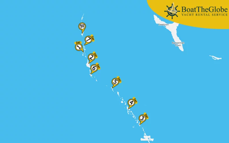
Day 1. Highbourne Cay – Norman’s Cay
9.8 nm
Our first stop is Norman’s Cay. It is one of the most fascinating islands of the Exumas, as the area is surrounded by an ancient coral reef. The conditions are suitable for all kinds of waterfront activities, but the place is also perfect for a relaxing afternoon. The remains of drug lord Carlos Lehder’s plane lie beneath the sea. It is a classic diving spot, as the plane is still intact, providing a home for tropical fish and corals. We can anchor at several parts of the island. Boats that are well-suited to strong waves may use the area between Battery Point and Norman’s Cut. As for vessels with a smaller draft, they can anchor near Boot Cay.
We can find other anchorages on the southeastern side between the dock and the plane wreck. The area is well-protected against winds, and the depth of water is around 2 metres. Read more about what to do in Exumas or yacht rental in Exumas
Day 2. Norman’s Cay – Shroud Cay
3.7 nm
Shroud Cay is located at the northern end of Exumas Cay Land and Sea Park. A wonderful river runs through the island, leading to an amazing beach. The remains of an old and abandoned camp can still be seen on the beach; it was used as a base by drug smugglers during the 1980s. We can use the mooring buoys around the island and the established boat slips for a certain fee.
Day 3. Shroud Cay – Staniel Cay
29.8 nm
Staniel Cay is among the most favourable destinations of the sailors in the Exumas.
Thunderball Grotto can be found on this island – the place got its name from a 1965 James Bond movie which was shot here. The island has an amazing yacht marina called Staniel Cay Yacht Club. They can accommodate 18 boats, and they provide fuel, access to electricity, water and ice. The depth of water is between 2 and 3 metres. There are other anchorages in the area near Sampson Cay. This sandbank can be found the app. 5 kilometres further; we have the opportunity to safely anchor on the shallow waters.
Day 4. Staniel Cay – Compass Cay
7.7 nm
Compass Cay also belongs to Exumas Cays Land and Sea Park. There is a meandering mangrove river passing through the island, at the end of which we can find Rachel’s Bubble Bath. This unique “pool” is fed by the ocean – the flowing water crashes against the coral reef, which practically makes the pool a natural jacuzzi. The yacht marina of the island is quite stranded, with only basic amenities. We can also anchor a bit farther outside, but the area can only be used for a fee. There is another shelter in the southern direction with great anchorages. It is a very quiet and peaceful spot, but they can only accommodate 10 boats altogether.
Day 5. Compass Cay – Waderick Wells Cay
9.4 nm
Waderick Wells Cay is one of the best-protected islands of Exuma National Park. The port is protected from all directions, making it very popular among sailors. Tying up our boat is only allowed outside the marking buoys, at Emerald Rock. It is forbidden to anchor near the coral reef. The island has many great anchorages to offer, but the northern part is not ideal for anchoring. We can find information on the fees on the website of Exuma Park. There is an amazing beach, as well as dozens of sights to see. It is definitely worth spending an afternoon here.

Day 6. Waderick Wells Cay – Hawksbill Cay
10.7 nm
Hawksbill Cay is also a part of Exuma Cays Land and Sea National Park. It is a very quiet and peaceful spot. They have no established ports, so we can only anchor at the designated mooring buoys. The depth of the water is app. 2 metres.
Day 7. Hawksbill Cay – Little Norman’s Cay – Highbourne Cay
11.6 nm
Our last stop is Little Norman’s Cay. The sandbank – only two kilometres in length – will be a perfect closure to our trip on the Exumas. There is buzzing sealife and a beautiful beach here. The island is well-protected and has safe anchorages to choose from.
7 Days the Exumas sailing tour
We will begin this trip on the largest island of the Exumas, Great Exuma. We will navigate towards the north, all the way to Highbourne Cay. It is a longer round-trip with greater distances, making it possible to sail around almost the entire chain of islands. We can explore the most exciting islands in the area and get a taste of the authentic Bahamian maritime life.
Day 1: George Town – Lee Stocking Island (22.8 nm – Sailing time*: about 4 hours), Day 2: Lee Stocking Island – Great Guana Cay (26.5 nm – Sailing time*: about 4.5 hours), Day 3: Great Guana Cay – Shroud Cay (34.6 nm – Sailing time*: about 5.5 hours), Day 4: Shroud Cay – Highbourne Cay (12.2 nm – Sailing time*: about 2 hours), Day 5: Highbourne Cay – Norman’s Cay (9.8 nm – Sailing time*: about 2 hours), Day 6: Norman’s Cay – Big Farmer’s Cay (50.1 nm – Sailing time*: about 8 hours), Day 7: Little Farmer’s Cay – Emerald Bay – George Town (27.8 nm – Sailing time*: about 4.5 hours)
* – an average 43 ft sailing yacht, with average weather conditions, sails around 6-7 knots per hour.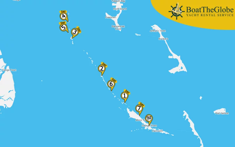
More Bahamas sailing
Marine gas near the Exumas
- EXUMA YACHT CLUB: GPS Coordinates : 23.504422, -75.768282
- EXUMA DOCKING SERVICES: GPS Coordinates: 23.503980, -75.767437
- EMERALD BAY MARINA: Depth: 4 m, GPS Coordinates: 23.630300, -75.916910
- LITTLE FARMER’S CAY YACHT CLUB: Depth: 2.5 m, Working time: 8-22, GPS Coordinates: 23.964241, -76.323389
- STANIEL CAY YACHT CLUB: Depth: 3.5 m, Working time: 8-21, GPS Coordinates: 24.172347, -76.445368
- HIGHBOURNE CAY MARINA: Depth: 2.5 m, Working time: 8-17, GPS Coordinates: 24.708938, -76.821578
The Exumas are a true gem of the Bahamas – a paradise for sailing enthusiasts, regardless of their experience on the sea. Waters are quiet on the west, meanwhile the east welcomes us with the open ocean. We can get to practically anywhere on our vessel in this area of over 180 square kilometres. We can disembark on wonderful islands, enjoy the sunshine of stranded beaches and explore the hidden treasures of the area on exciting trips. Our sailing adventure around the Exumas will be an unforgettable experience. Find Bahamas sailing routes, catamaran rental Bahamas, last-minute yacht charter Bahamas, sailing holidays Bahamas skippered, bareboat catamaran charter Bahamas, Bahamas sailing yacht charter bareboat, crewed yacht charter Bahamas, bareboat yacht charter Bahamas, Bahamas luxury yacht charter, yacht rental Bahamas, catamaran charter Bahamas, sailboat charter Bahamas, motor yacht charter Bahamas
HELP ME TO CHOOSE THE PERFECT BOAT